Help Docs
MacENCx64 Online Documentation
Weather
Weather allows wind speed, wind direction, pressure, air temperature, sea temperature, wave height, precipitation and currents to be plotted on the chart. MacENCx64 uses the standard GRIB (Gridded Binary data) format for weather forecasts. GRIB are output files generated by computer forecasting models.
They are tremendously more compact than regular weather charts and because of their size are very well suited for download via wireless means. The largest producer of GRIB weather is NOAA although other organizations such as the military and research institutions also generate GRIB files. NOAA GRIB files are the best ones suited for marine forecasts.
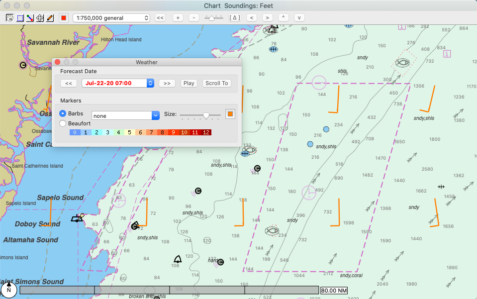
A GRIB file may be loaded via Weather -> Open Grib… on the menu bar. GRIB files typically have forecasts for more than one date and/or time. MacENCx64 will select the closest date to the current date. A different date can be selected on the Weather panel. Use Weather -> Show to turn on or off the weather plot and the Weather panel.
You can obtain a GRIB via the SailDocs service by selecting Weather -> Request GRIB on the menu for the currently opened chart area. The chart must be between 3 degrees and 180 degrees in width and height except in the case of the World chart in which case a GRIB of 40 degrees by 40 degrees will be requested. The GRIB will come to your email inbox. (Set your email address in the MacENCx64 Preferences if you use macOS native mail app; otherwise, check the Manual box to send the GRIB request via another installed mail application).
The GRIB will have the requested data and be for 00, 12, 24, 36, 48, 60, and 72 hours. You can transfer GRIB data to Google Earth by selecting Weather -> Transfer To KML.
-
Note: Surface Wind (COAMPS) will always be 0.2 degree intervals, 48 hours on 6 hour intervals and limited to three regions: East-Pacific: 29n,60n,160w,114w / West-Altantic: 20n,55n,093w,055w / Cent-Am and Carib: 00n,32n,120w,060w.
-
Note: Currents will always be 0.25 degree intervals, 120 hours on 12 hour intervals and limited to 20S to 70N, Atlantic ocean from North America to Africa/Europe.

Use Next Forecast >> and Previous Forecast << buttons to step forwards and backwards in forecast time. Use the Play button to cycle through the forecasts. The Scroll To button will move the chart to the GRIB data. The forecast time is in system local time.
When the Contour is selected, contours for pressure, air or sea temperature, or precipitation rate will be displayed.
When the Barbs radio button is selected wind speed is indicated by ticks on the wind direction vectors. Each full tick represents a wind speed of ten depending on the Units setting in preferences.
When the Beaufort radio button is selected, wind speed is indicated by the color of the arrow according to this scale:
| Force Color Number | Wind (Knots) | Classification |
|---|---|---|
| 0 | Less than 1 | Calm |
| 1 | 1 - 3 | Light Air |
| 2 | 4 - 6 | Light Breeze |
| 3 | 7 - 10 | Gentle Breeze |
| 4 | 11 - 16 | Moderate Breeze |
| 5 | 17 - 21 | Fresh Breeze |
| 6 | 22 - 27 | Strong Breeze |
| 7 | 28 - 33 | Near Gale |
| 8 | 34 - 40 | Gale |
| 9 | 41 - 47 | Strong Gale |
| 10 | 44 - 55 | Storm |
| 11 | 56 - 63 | Violent Storm |
| 12 | 64 or greater | Hurricane |
The size and color of the wind markers can be set with the slider and color chooser. MacENCx64 only plots the data points contained in the GRIB file, so it may be required to zoom out to see the extent of the GRIB data.