Help Docs
MacENCx64 Online Documentation
Waypoints
A waypoint is a position on a chart that you want to make note of. Besides for marking a position, waypoints can be used to navigate to their position.
Waypoints can be created by:
-
double clicking on the Chart window when the measure or waypoint move mode is selected on the MacENCx64 toolbar or
-
pressing the New button on the Waypoint window or
-
control clicking and selecting the New menu item on the context menu.
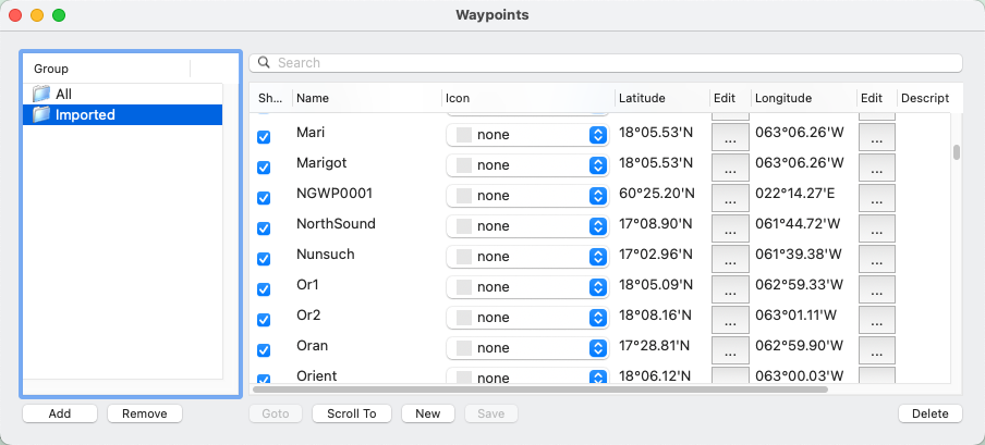
Once a waypoint is created it can be edited, deleted, renamed, dragged to a group, scrolled to, or saved. All of this occurs in the Waypoint window which can be opened either by creating a waypoint or selecting Waypoints -> Open on the menu bar.
Single click to select a waypoint, then single click again a field in the Waypoint window such as Name or Description to edit it. Make sure latitude and longitude are entered as described in Using Charts Position Format section.

An individual waypoint can be shown or not shown on the chart by selecting the checkbox Show next to it. All waypoints can be shown or not with the menu item Waypoints -> Show on the menu bar.
command click on the waypoint name on the chart to select it in the Waypoint window. When mode is measure or waypoint move, double click on the waypoint name on the chart to edit it.
When waypoint Mode is set  , they can be moved on the chart. Move the cursor over the waypoint name. The cursor will change to a move cursor. Drag the waypoint to the location desired on the chart.
control clicking on the waypoint name on the chart displays a context menu with the menu items to: Goto, Edit, Delete, and Hide the selected waypoint.
control clicking on a navaid (i.e. buoy, beacon, daymark, fog signal) on the chart displays a context menu with menu items to Goto or create a New waypoint.
If the GPS panel is opened (via menu item GPS -> Connect) and a current position is transmitted from the GPS , you can navigate to a waypoint by selecting it and pressing the Goto button. This makes the waypoint active. The details of the active waypoint will be shown in the Navigation panel. An active waypoint can be canceled by selecting Cancel Goto on the Navigation panel. A solid blue line will be drawn from the current position to the waypoint. A solid red line will be drawn from the position where the waypoint was activated to the waypoint. Deviation from the red line is cross track error. Cross track error can be reset by re-selecting the waypoint and pressing the Goto button.
The Scroll To button will scroll the chart to the selected waypoint.
The Arrival Alarm can be enabled on the Waypoints menu to be notified when the active waypoint is within Waypoint Approach Distance set in the Preferences window OR the GPS position crosses the line perpendicular to the waypoint origin line which passes through the waypoint. The Arrival Alarm will be enabled whenever a waypoint is made active.
The Cross Track Alarm can be enabled on the Waypoints menu to be notified when cross track error to the active waypoint is equal to or greater than Cross Track Approach Distance set in the Preferences window.
A waypoint is also created and listed in the Waypoint window if the GPS is navigating to one (typically done by pressing Goto on the GPS). When this is done a Waypoint drawer will open from the GPS panel. If the Goto check box is selected in the GPS panels Waypoint drawer it will become the active waypoint. When this occurs the GPS waypoint will take precedence over any other waypoint that is active.
Waypoints can be imported or exported to a file via Waypoints -> Transfer menu. For importing, the waypoints CSV file must be in the following format:
name,latitude,longitude,description <newline>
name,latitude,longitude,description<newline>
latitude and longitude must be in the same format as the selected in Preferences -> Position Formats.
Import and export support CSV file, a GPX ![]() file or a Google Earth Versions
file or a Google Earth Versions ![]() KML or KMZ file. Dragging a group to a
Finder folder will create a GPX file. Routes can be saved to cloud storage (such as iCloud or Dropbox) and shared with other applications including the popular mobile application iNavX.
KML or KMZ file. Dragging a group to a
Finder folder will create a GPX file. Routes can be saved to cloud storage (such as iCloud or Dropbox) and shared with other applications including the popular mobile application iNavX.
Waypoints can be copied to and from the GPS via Waypoints -> Transfer -> To/From GPS. Currently Garmin, Magellan, Furuno and Other protocols are supported of directly connected (increasingly uncommon setup). Before the transfer begins the GPS panel will automatically be closed. Make sure the correct brand of GPS is selected in the GPS Settings drawer. Garmin GPS will need to be put in Data Transfer/Slave or 'GARMIN' Mode before a waypoint transfer can be performed.
Other GPS must support the $GPWPL NMEA 0183 message. Since GPS's don't support long unrestricted waypoint names or descriptions they will be reformatted and truncated when being transferred.
Sadly, no manufacturer has implemented NMEA 2000 waypoint / route transfer.